


Tandi Sangam
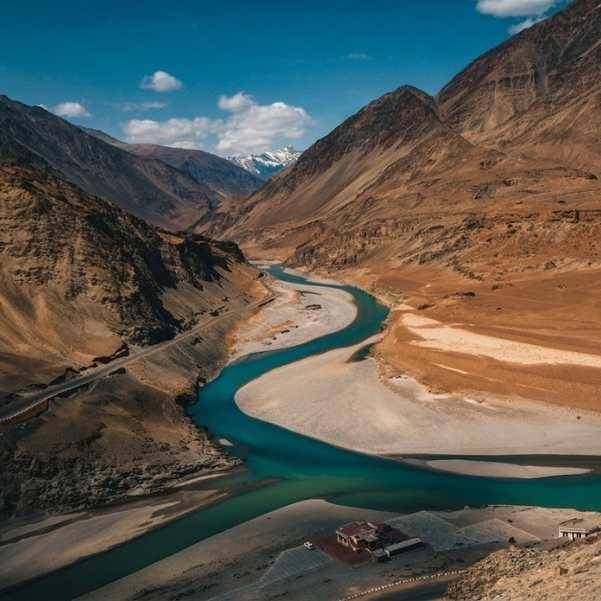
The confluence of the Chandra and Bhaga rivers in Lahaul at around 2,570 metres, where the Chenab begins and most travellers stop for 20 minutes on the drive between Manali and Keylong
What makes it special
Tandi Sangam is the point in the Pattan valley of Lahaul where two glacier fed rivers, the Chandra and the Bhaga, meet and become the Chandrabhaga, the river that flows out of Himachal into Jammu as the Chenab. The Chandra rises near Chandra Tal below the Kunzum Pass, the Bhaga near Suraj Tal below Baralacha La, and the two take long, separate routes around the Lahauli mountains before finally joining here. On the ground, the sangam is a wide, flat gravel basin below a small village, with a tarred bridge running above it on the Manali to Leh highway. That bridge is where most travellers stop, lean on the railing for two minutes, take a photo, and move on.
Honest framing most travel pages skip. Tandi is not a sightseeing destination in the Chandratal or Kunzum sense. It is a geographical marker and a working village halt. There is a bridge viewpoint, a small dhaba or two on the roadside, a fuel pump about a kilometre up the village road, and a scatter of houses on the slopes above. Twenty minutes is enough for most people. An hour if you walk down to the bank and sit by the water for a bit. If you came hoping for a built up ghat with shops and facilities, you will be disappointed. If you accept what it actually is, which is the quiet, working confluence of two rivers in a village that has been cremating its dead on these banks for centuries, it is one of the more affecting pauses on the drive into Lahaul.
The place carries two very different reasons to matter, and they sit side by side. Spiritually, the sangam is one of the most significant sites in the Lahaul valley, treated by locals with the kind of reverence Hindus elsewhere reserve for Haridwar or Prayag. It is often cited as one of the eight Mahashamshans, or great cremation grounds, of India. The ashes of former Prime Minister Atal Bihari Vajpayee and VHP leader Ashok Singhal were immersed in the Chandrabhaga here, among many others. Practically, Tandi is the reference fuel halt on the Manali to Leh highway. The pump here has been the standard refill point for decades, and even with a newer pump reported near Keylong (operational since September 2021), most bikers and self drivers still top up at Tandi out of habit and caution. Both identities, spiritual and logistical, live on the same bend in the road.
Is Tandi Sangam worth stopping at?
Yes, as a short halt on the drive between Manali and Keylong or Leh. Twenty minutes covers the bridge viewpoint, a fuel top up, and a chai from one of the dhabas. Do not plan it as a day destination. The interest here is geographical and religious, not scenic in the postcard sense. If you slow down for an hour and walk closer to the water, the quiet weight of the place grows on you.
How long should you stop at Tandi?
For most travellers, 15 to 30 minutes. That covers the bridge viewpoint, a fuel top up at the village pump, and tea from a roadside stall. Stretch it to an hour if you want to walk down closer to the confluence or visit Tupchiling Gompa. If Guru Ghantal Monastery above the village is on your list, budget a full half day, the trek from Tupchiling is strenuous and takes 3 to 4 hours up.
Is Tandi still the last petrol pump before Leh?
Almost. A newer pump has been reported near Keylong (operational since September 2021), so technically not the very last one. But the Tandi pump remains the reference refill point on the Manali to Leh highway, and most bikers and self drivers still top up here. The next pump after Tandi or Keylong is at Karu near Leh, roughly 330 to 350 km further. Fill up at Tandi is still the safe rule.
Quick facts
Everything you need to know at a glance
At a glance
On the ground
Seasonal weather
Suitable for
How to reach Tandi Sangam
5 approach routes with seasonal access
From Manali (via Atal Tunnel)
Year round via the tunnel. Road conditions after heavy rain or snow can vary.The standard approach. From Manali, take NH3 south to the Atal Tunnel south portal at Dhundi. The tunnel is 9 km long and generally takes 15 to 20 minutes to cross at the posted speed. Exit the north portal, continue along the highway through Sissu (about 7 km past the portal), Gondhla, and drop into Tandi bridge another 22 km further. On peak weekends and holidays, traffic can queue at the south portal for 30 to 60 minutes, leave Manali by 8 or 9 AM to reach Tandi by late morning. Note that many older travel pages still cite 110 km for this route, which is the old pre tunnel distance via Rohtang Pass. The new distance via the tunnel is about 70 km.
Fuel stop: Fill up in Manali. Tandi is itself the next fuel point.
From Keylong
Year roundA very short drive if you are already in Keylong. The road follows the Bhaga river south until it drops into the Tandi bridge. Useful if you base in Keylong and want a morning walk down to the confluence, or if you are returning from Jispa and want to stop for fuel and a chai.
Fuel stop: Tandi is the pump. Keylong also has one since 2021.
From Sissu
Year roundThe most common intermediate stretch. From Sissu, the road follows the Chandra river through Gondhla, past the old Gondhla fort, and drops into the Tandi confluence. A natural lunch or tea stop if you are moving from a Sissu overnight towards Keylong or Jispa.
Fuel stop: Tandi itself
From Jispa
Year roundComing south from Jispa or Darcha on the Leh route, Tandi is your refuelling point before the tunnel. The drive follows the Bhaga river south through Keylong, then 7 km further to the bridge. Fill up here, grab a chai, and you are about two hours from Manali.
Fuel stop: Tandi itself
From Delhi or Chandigarh
Year roundNobody drives all the way from Delhi or Chandigarh to Tandi in one go. The realistic plan is an overnight Volvo or drive to Manali, sleep a night, and continue through the tunnel to Tandi and onwards the next morning. If you are heading to Leh or Jispa and Tandi is just the fuel stop, plan your Manali morning departure to reach the pump by late morning with time in hand.
Fuel stop: Chandigarh, Swarghat, Bilaspur, Sundernagar, Mandi, Manali
Best time to visit
Season-by-season breakdown to help you plan
Clear skies, both rivers running well, the best all round window
A good time to see the confluence. The Chandra is swelling with melt from the Kunzum side, the Bhaga running full from Baralacha, and the bridge view is at its cleanest. Days are warm enough for a t-shirt, nights still need a jacket. The Tandi pump is reliably open, the dhabas on the highway reopen from mid May as Leh traffic starts. June is the single best month, warm days, clean light, Leh route open, and not yet peak crowd.
Rivers at full power but both run muddy, and the approach can see landslides
The confluence is at its most dramatic in terms of volume, but also at its muddiest. The glacial melt and monsoon combined turn both rivers silty brown, so the distinct colour mixing at the sangam is less visible. Tandi itself sits in a partial rain shadow, direct rain is less frequent than in Manali, but the highway approach through the Atal Tunnel exit and onwards can see landslides and debris flows. Build a buffer day into your plan and confirm road status before leaving Manali. This is peak Leh traffic season, the pump queue can be long on some days, and booking ahead matters at Keylong and Jispa.
The sharpest light of the year and the cleanest version of the confluence
If you can time it, late September to mid October is the best window to actually see the sangam. The monsoon settles, both rivers clear up, and the distinct grey of the Chandra and the slightly greener Bhaga become visible again at the meeting point. Traffic thins after the first week of September as the Leh season winds down. Nights get cold quickly by October, carry a proper warm layer. The Baralacha La road typically stays open through September, first snows can close it anywhere from early to late October.
Snow, genuine cold, and access that depends on the day
The Atal Tunnel keeps the road to Keylong open year round, which means Tandi stays technically reachable even in deep winter. In practice, the 7 km from Keylong and the bridge area itself can be icy after snowfall, and dhabas along the highway mostly shut from November to April. Temperatures drop well below freezing at night. The fuel pump runs on shorter hours, confirm before you rely on it. Winter visits are only practical for experienced Himalayan travellers with proper gear and flexible plans. Cremations continue year round regardless of weather, respect the site if you visit off season.
Things to see & do
8 experiences at Tandi Sangam
Stop at the Tandi bridge viewpoint
10 to 20 minutesThe bridge on the Manali to Leh highway is where every vehicle slows down. The confluence sits directly below on the downstream side, the Chandra coming in from the left after its long detour around Lahaul, the Bhaga from the right after dropping down from Baralacha. Walk to the middle of the bridge, lean over the downstream railing, and in clear conditions you can see the two rivers mixing into a single Chandrabhaga. The difference in colour shows best in late spring and autumn, it is muddy all round in peak monsoon. Keep to one side of the road, the bridge is narrow and trucks come through fast.
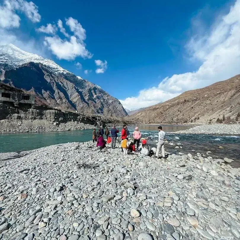
Walk down to the banks
30 to 45 minutesA rough footpath drops from the roadside down to the river bank near the cremation area. Locals use it daily. The walk is short but the gravel is uneven and the climb back up feels longer than the descent. At water level the scale of the confluence makes more sense than from the bridge, the two rivers meeting at chest height right in front of you. Visit respectfully. If funeral rites are in progress, stay well back and do not photograph. The stones near the water are often slippery, wear shoes with proper grip. This is the version of Tandi that most drive through travellers never actually see.
Fill up at the Tandi petrol pump
10 to 20 minutesThe pump is about a kilometre up the village road from the bridge, signposted. It has been the reference refill point on the Manali to Leh highway for decades. If you are heading towards Ladakh, this is where you top up your tank and, if biking, also fill any spare jerry cans or cold drink bottles. The next pump after Tandi or Keylong is at Karu near Leh, roughly 330 to 350 km further. Queues can build in peak season, especially on weekend mornings when bike groups are rolling through. Confirm operating hours if you are arriving very early or late, and know that winter hours can be shorter.
Pause at Tupchiling Gompa
20 to 30 minutesTupchiling is a small working monastery on a short uphill path from near the Tandi bridge. It serves as the caretaker gompa for Guru Ghantal Monastery above, and most of the sacred relics from Guru Ghantal have been moved here for safekeeping, including some of the wooden idols that make the upper monastery historically important. A quiet 20 minute stop if the door is open and a lama is present. Ask before taking photographs inside. This is also where you collect the key and the directions if you plan to continue up to Guru Ghantal.
Trek up to Guru Ghantal Monastery
Half day to full dayGuru Ghantal, also called Gandhola Gompa, is believed to be among the oldest Buddhist monasteries in Lahaul. Local traditions variously credit Padmasambhava, Rinchen Zangpo, or a lama named Guru Ghantapa with founding it, and the building in its current form is generally dated around the 10th to 12th century. It sits on a ridge above Tupchiling village near the confluence. The trek from Tupchiling is steep, with reports ranging from 3 to 4 hours up depending on fitness, and shorter on the way down. Ask at Tupchiling for the key before climbing, the gompa is often locked and a wasted climb is a real risk. Not a casual add on to a highway stop. Carry water, snacks, good shoes, and do not attempt in rain or snow.
Tea at a highway dhaba
20 to 40 minutesA couple of basic dhabas and a small cafe operate near the bridge and along the approach road. Expect chai, Maggi, momos, and a plate of dal rice or rajma chawal if the timing is right. Nothing fancy, nothing bad. A welcome break if you have been driving since Manali and still have Keylong, Jispa, or Baralacha ahead. Carry small cash, UPI is unreliable here.
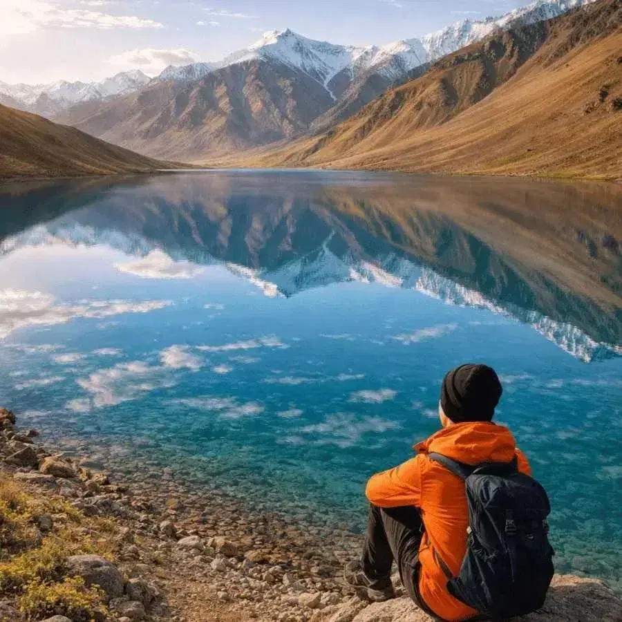
Sit quietly by the water
As long as you likeIf you have an hour to spare and the confluence interests you beyond a photograph, walk down to the bank, find a flat stone, and sit. The sound of the two rivers meeting is genuinely different from either of them alone, somewhere between a hiss and a low roar depending on season. No signal, no schedule. People who have lived in Lahaul for years will tell you this is when the place actually works on you. Worth the hour if you can spare it.
Photograph the confluence from the bridge
15 to 30 minutesThe clean shot is from the downstream railing of the bridge in mid morning or late afternoon light, when the V of the confluence is well lit and the colour difference between the two rivers shows. A 24 to 70 mm range covers most of it, a polariser helps cut river glare. Do not photograph the cremation area if rites are in progress, this is a working shamshan for the local community and the sentiment on this is strong. Ground photography from the bridge and the upper bank is enough, keep drones grounded here.
Know before you visit Tandi Sangam
Essential information for planning your visit
Nearby attractions
Other places worth visiting nearby
 ~7 km · 15 to 20 min drive
The district headquarters of Lahaul and Spiti, with the only proper market in the valley, an ATM, the Shashur and Kardang monasteries, and the second fuel pump on this stretch. The natural base if you want to pair a Tandi stop with a proper Lahauli town halt.
 Tupchiling is a short walk from the bridge, Guru Ghantal is a 3 to 4 hour uphill trek from there
Tupchiling is the working caretaker gompa at the base, a quick 20 minute visit. Guru Ghantal above is believed to be among the oldest monasteries in Lahaul and houses wooden idols unusual for the region. Serious half day trek, not a casual add on. Ask for the key at Tupchiling before climbing.
 ~22 km · 35 to 45 min drive towards Manali
The first village past the Atal Tunnel, with a waterfall visible from the highway, a small lake, and a helipad sunset viewpoint. A natural pair with Tandi as a short Lahaul circuit.
 ~28 km · 45 min to 1 hour drive towards Leh
A quiet Lahauli hamlet on the Bhaga river with riverside campsites, a small monastery, and the calmest overnight halt on the Leh road. The common next stop after Tandi for travellers heading further north.
 ~11 km · 20 min drive towards Sissu
A several centuries old wooden and stone fort in Tibetan style on the road between Sissu and Tandi. Small but worth a 20 minute stop for the architecture and the view down the Chandra valley.
 ~53 km · 2 hours drive along the Chandrabhaga
The second biggest town in Lahaul, reached by branching off near Tandi bridge and following the Chandrabhaga downstream. The 11th or 12th century wooden Mrikula Devi Temple is the draw, known for its deodar wood carvings. A separate day trip from a Keylong base, not a Tandi detour.
 ~75 km · 2.5 to 3 hours drive
Source of the Bhaga river, a small alpine lake at around 4,890 m near the Baralacha La pass. A full day out from a Keylong or Jispa base, accessible June to October depending on snow. Do not linger at the pass, the altitude is serious.
 ~130 km via Gramphu and Batal · 6 to 7 hours
Source of the Chandra river, a natural crescent shaped glacial lake at around 4,300 m. Not a day trip from Tandi. Plan it as part of a Spiti circuit via the Kunzum Pass.
 ~145 km via Gramphu and Batal · 7 to 8 hours
The high pass at around 4,551 m connecting Lahaul to Spiti, generally open June to October. The waters that feed the Chandra rise in this basin. Part of a multi day Spiti circuit, not a Tandi day trip.
Our Packages with Tandi Sangam
Curated trips that include a visit to Tandi Sangam

Planning a trip that includes Tandi Sangam?
Not sure where to start? Just tell us your dates and what you're looking for, and we'll help you plan a trip that actually fits you.
Frequently Asked Questions
Related guides
- Best Time To Visit Sissu in 2026: Month Wise Weather, Snow and Road Guide
- Manali To Sissu Road Trip Guide 2026: Route, Distance, Road Status, Cost And Local Tips
- Sissu In September 2026: Best Time For Lahaul Road Trips
- Sissu In August 2026: Monsoon Weather, Road Status, Itinerary And Safety Guide
- Sissu In July 2026: Weather, Waterfalls & Road Trip Guide
- Sissu In June 2026: Snow, Weather & Best Experiences